Getting to Santa Cruz
Santa Cruz is within driving distance of some of the biggest cities in California, and is also accessible by bus, plane, or boat. It is a picturesque seaside town full of character that deserves a stop and might just become your next vacation spot!
Santa Cruz is within driving distance of some of the biggest cities in California, and is also accessible by bus, plane, or boat. It is a picturesque seaside town full of character that deserves a stop and might just become your next vacation spot!
By Car:
Santa Cruz is about a 30-minute drive from San Jose and the Silicon Valley, 45 minutes from the Monterey/Carmel area, and 75 minutes from San Francisco. On summer weekends and holidays, the traffic can be heavy (and the drive times longer), so be sure to leave enough time to be able to enjoy everything Santa Cruz has to offer.
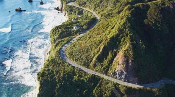
Scenic Highway 1 stretches along the breathtaking Pacific Coast and Monterey Bay from San Mateo County in the north to Monterey County in the south. Highway 17 is a beautiful drive from Los Gatos to Santa Cruz through the redwoods and the Santa Cruz mountains.
North:
East:
Scenic Highway 1 stretches along the breathtaking Pacific Coast and Monterey Bay from San Mateo County in the north to Monterey County in the south. Highway 17 is a beautiful drive from Los Gatos to Santa Cruz through the redwoods and the Santa Cruz mountains.
North:
- The fastest route from San Francisco and other points north is through San Jose: Take Interstate 280 south or US Highway 101 south to CA Highway 85 and then take CA Highway 17 south to Santa Cruz.
East:
- From Oakland, other East-Bay cities, and Sacramento: Take Interstate 80 west to Interstate 880 south which becomes CA Highway 17 to Santa Cruz.
- From Los Banos, Merced, Fresno, and other points south: Take Interstate 5 or CA Highway 99 to CA Highway 152 west to CA Highway 156 west CA Highway 1 north.
- From Salinas and points south on CA Highway 101: Take CA Highway 183 West to Highway 1 north.
- From the Monterey/Carmel area: Take CA Highway 1 north.
- Real-time traffic conditions and highway webcams in the Santa Cruz County area Regional Transportation Commission's Commute Solutions Traffic Conditions webpage
- For current road conditions by phone, call the CalTrans (California Department of Transportation), (800) 427-ROAD
- Visit the California Department of Transportation website and enter the number of the highway you're taking (e.g., Highway 1, 9, 17, 129, 152, or 156)
- Call 511 or visit http://511.org/ for up-to-the-minute Bay Area traffic, transit, rideshare, and bicycling information, 24 hours a day, 7 days a week from anywhere in the nine-county Bay Area
By Bus:

The Santa Cruz Metro and Train Transit Information
The Santa Cruz Metro connects many of the neighboring cities to Santa Cruz and even has a bus line that connects San Jose to Santa Cruz. The Metro has many bus lines that connect the UC Santa Cruz Campus with Downtown Santa Cruz in order to provide service to students who need to get to and from campus. The Metro is part of the Santa Cruz Metropolitan Transit District, which was formed in 1968 to provide better public transportation in Santa Cruz, Capitola, and Live Oak. The boundaries of the district were then expanded to better serve the communities throughout Santa Cruz County.
The Santa Cruz Metro provides a bus line, Amtrak Highway 17 Express, to San Jose's Diridon Station. This bus line connects Santa Cruz with the Amtrak Train Station in order to make it more efficient and accessible for individuals in Santa Cruz.
Santa Cruz Metro Main Page
Santa Cruz Metro Schedule
Monterey-Salinas Transit
Amtrak Highway 17 Express Schedule
Amtrak Main Page
By Plane:
The nearest airports for commercial travel include San Jose International Airport (SJC),Monterey Peninsula Airport (MRY), San Francisco International Airport (SFO), andOakland International Airport (OAK). Watsonville Municipal Airport is a public general aviation airport. Shuttle and taxi service are available from all airports.
Mineta San Jose International Airport
1701 Airport Boulevard
San Jose, CA 95110
(408)-392-3600
Mineta San Jose International Airport Website and Information
Oakland International Airport
1 Airport Drive
Oakland, CA 94621
(510)-563-3300
Oakland International Airport Website and Information
San Francisco International Airport
San Francisco International Airport
San Francisco, CA 94128
(650)-821-8211
San Francisco International Airport Website and Information
Monterey Regional Airport
200 Fred Kane Way #200
Monterey, CA 93940
(831)-648-7000
Monterey Regional Airport Website and Information
Watsonville Municipal Airport
100 Aviation Way
Watsonville, CA 95076
(831)-768-3575
Watsonville Municipal Airport Website and Information
Parking at Watsonville Municipal Airport: Automobile parking is available adjacent to the terminal building. Pilots who have their own hangars normally park their automobiles in the hangar.
By Boat:
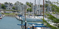
The Santa Cruz Small Craft Harbor provides permanent moorage and guest berthing to boaters, averaging 15,000 visitor-nights per year. Santa Cruz Harbor is situated between Monterey Harbor and Pillar Point Harbor of Half Moon Bay. Coordinates of Walton Lighthouse at the harbor entrance are 36° 57’ 36” north, 122° 00’ 06” west.